The land–sea temperature difference (LSTD) is a key factor regulating regional climate. Under the background of global warming, the warming rates of land and ocean differ, and such thermal imbalance may intensify the regional hydrological cycle, thereby influencing the frequency and intensity of extreme precipitation events. Recently, a research team from the Yantai Institute of Coastal Zone Research, Chinese Academy of Sciences, in collaboration with the Institute of Applied Physics of the Russian Academy of Sciences and Zhejiang Ocean University, conducted a systematic study on the variation of land–sea temperature difference (LSTD) and its relationship with extreme precipitation in Eastern China.
Based on MODIS satellite remote sensing data from 2001 to 2021 and observations from 399 meteorological stations across Eastern China, the study conducted a multi-scale analysis of LSTD and extreme precipitation. The results show that LSTD in Eastern China is generally negative and exhibits a decreasing trend, with more pronounced changes in near-coastal areas. Spatially, around 30°N serves as a boundary: LSTD tends to decrease in northern regions but increase in southern regions.
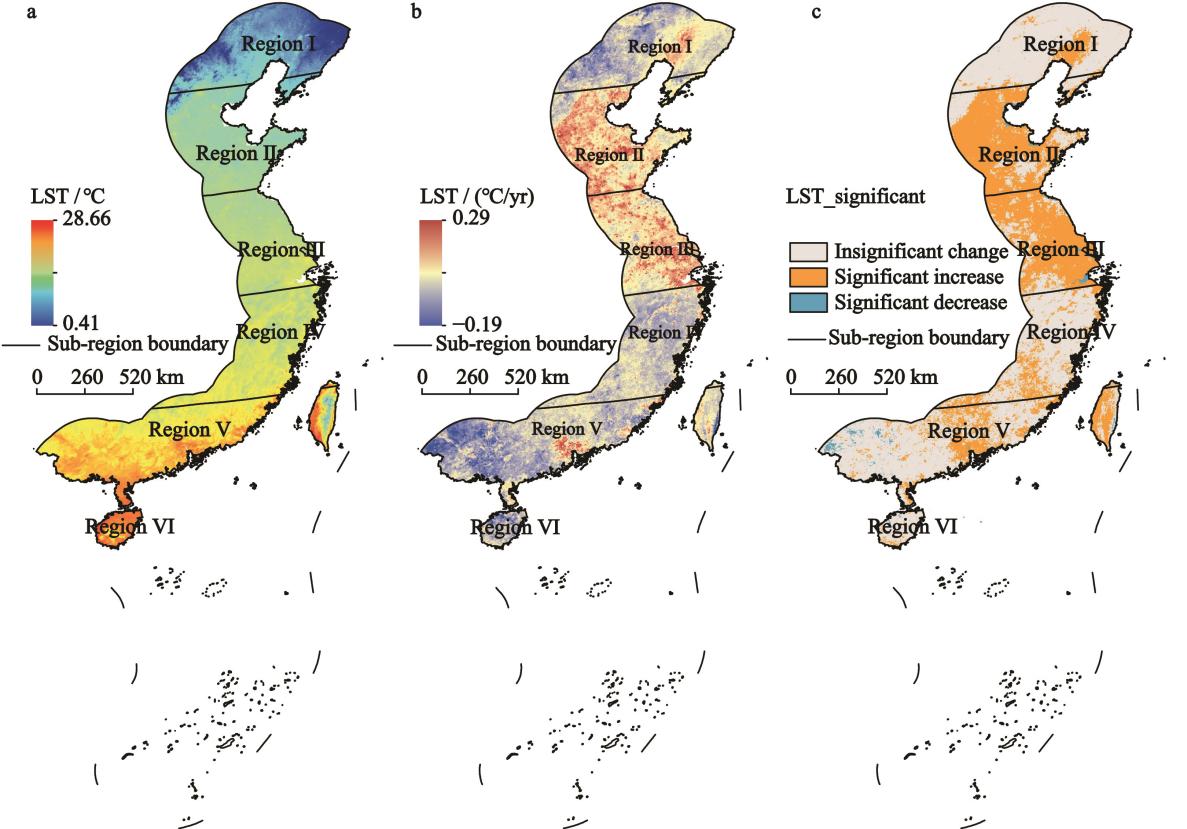
Fig.1 Spatial distribution of the multi-year average (a), annual tendency rate (b), and significance (c) of land surface temperature (LST) during 2001–2021 in Eastern China
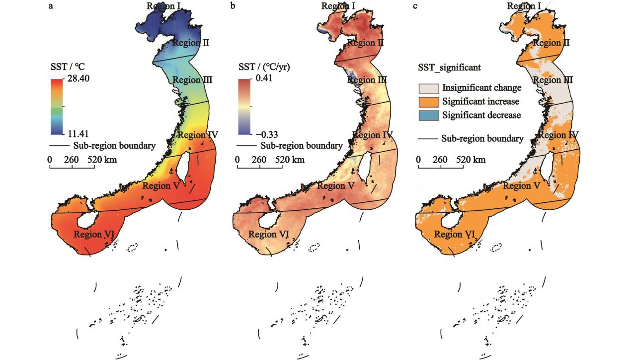
Fig.4 Spatial distribution of the multi-year average (a), annual tendency rate (b), and significance (c) of sea surface temperature (SST) during 2001–2021 in Eastern China
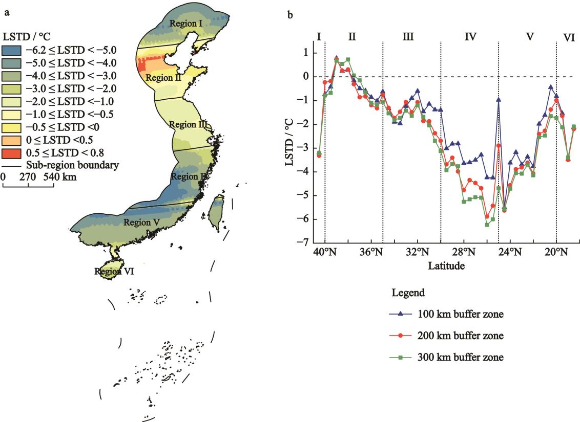
Fig.3 Spatial distribution of the multi-year average of land-sea temperature difference (LSTD) during 2001–2021 in Eastern China (a), and its latitudinal variation within 100 km, 200 km, and 300 km buffer zones (b)
Regarding extreme precipitation, the study found that very wet precipitation, the number of heavy precipitation days, and consecutive wet days all show increasing trends, while consecutive dry days exhibit a decreasing trend. The spatial pattern of extreme precipitation is characterized by higher values in the south and lower values in the north, with more significant changes observed south of the Yangtze River. Correlation analysis indicates that LSTD is positively related to heavy precipitation and wet-duration indices, but negatively related to dry-duration indices. These relationships are more pronounced in northern coastal areas and regions south of 30°N, highlighting the important role of land–sea thermal contrast in shaping regional precipitation patterns and its clear spatial heterogeneity.

Fig.4 Spatial distribution of correlation coefficient between the land-sea temperature difference and extreme precipitation indices during 2001–2021 in Eastern China
This study employs a unified remote sensing data source to ensure consistency between land and sea temperature data and introduces a multi-scale coastal buffer analysis method, improving the precision of LSTD characterization. The findings contribute to a better understanding of land–sea interactions and their climatic effects, and are of significance for climate adaptation and disaster risk reduction in coastal regions. The related results have been published in Chinese Geographical Science and Acta Ecologica Sinica. The research was supported by the National Natural Science Foundation of China and the Special Exchange Program of the Chinese Academy of Sciences.
Reference:
Lijie Dong, Xiaoli Wang *, Yuriy Titchenko, Xiyong Hou, Feng Gui. Variation of land-sea temperature difference and its relationship with extreme precipitation in Eastern China. Chinese Geographical Science, 2026, 36(3): 414-429.
Lijie Dong, Xiaoli Wang*, Feng Gui, Xiyong Hou. Spatial and temporal characteristics of land-sea temperature difference in Eastern China based on MODIS data. Acta Oceanologica Sinica, 2024, 44(14):6097-6110. in Chinese