Recently, the Coastal Wetland Evolution Mechanisms and Ecological Restoration Research Group (Kai Xiao Research Team) at the Yantai Institute of Coastal Zone Research, Chinese Academy of Sciences, has systematically elucidated the migration mechanisms of phosphorus from estuarine rivers at the sediment-water interface and the transformation and transport processes of nutrients in intertidal groundwater. This was achieved through a combination of methods including sediment phosphorus speciation analysis coupled with diffusion flux modeling, multi-depth groundwater sampling and dynamic monitoring, and stable isotope tracing with multivariate statistics. This series of studies provides crucial scientific evidence for a deeper understanding of the terrestrial drivers of nearshore eutrophication.
Achievement 1: Spatial variability of the phosphorus forms and diffusive flux across the sediment-water interface: insights from a typical small watershed to the national scale
Phosphorus, as a key limiting element controlling eutrophication in freshwater ecosystems, plays a vital role in understanding and managing water body eutrophication through its cycling processes within small watersheds. This research focuses on phosphorus cycling processes driven by agricultural activities, examining a typical agricultural small watershed in northern China and integrated nationwide data. It not only reveals the intrinsic patterns of sediment phosphorus cycling in small watersheds but also provides critical scientific basis for understanding and regulating water body eutrophication.

Fig. 1. Map of the study area indicating the relative location of the study site
To elucidate the migration and diffusion mechanisms of phosphorus at the sediment-water interface, the research team established 19 sampling points along the Mihe River Basin from upstream to downstream (Figure 1). In November 2024, surface sediment (0-10 cm) samples were collected, and the chemistry of the overlying water was simultaneously monitored. The study found that the phosphorus content in the sediments of the Mihe River Basin exhibited significant longitudinal differentiation, showing a decreasing pattern from upstream to downstream (Figure 2a). Furthermore, the migration of phosphorus from sediment to surface water was predominantly mediated by organic phosphorus (Figure 2b).
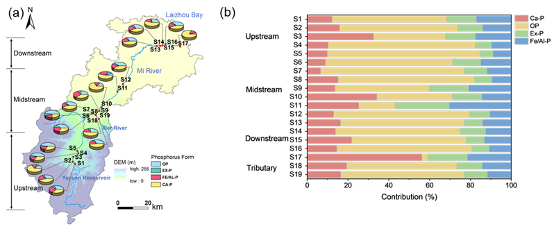
Figure. 2. Spatial distribution map of phosphorus speciation and diffusion flux
By integrating 2304 sediment total phosphorus content data points nationwide and analyzing the phosphorus diffusion flux in 14 small watersheds (Figure 3), the study elucidates the spatial distribution characteristics and transport-transformation patterns of sediment phosphorus in China. Results indicate that sediment total phosphorus content in the northwestern region is relatively low, comparable to that in the central-western and northeastern regions as well as the Mihe River Basin. Areas with high sediment phosphorus diffusion flux are primarily concentrated in southwestern China and along the coast, with most small watersheds exhibiting a trend of phosphorus release from sediment to the overlying water.
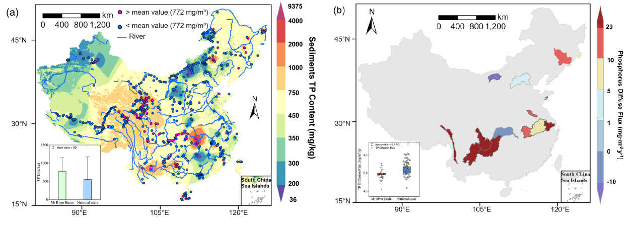
Figure. 3. Distribution map of total phosphorus content nationwide and phosphorus diffusion flux in small watersheds
Achievement 2: Vertical sediment stratification regulates dissolved nutrient dynamics and interface fluxes along the intertidal zone
Sandy beach and mudflat account for 31% and 14% of the world's ice-free coastlines, respectively (Figure 4a). Their intertidal aquifers serve as critical interfaces that regulate the "composition" and "flux" of nutrient input into the sea. Previous research often treated intertidal sediments as a homogeneous system. However, a pervasive vertical stratification structure, characterized by "fine-grained surface sediments overlying coarse-grained sediment layers" (Figure 4b, d), is commonly observed in reality. How this stratification influences the migration, transformation, and seaward transport fluxes of nutrients within groundwater, and its underlying mechanisms, remain unclear. Therefore, the research team selected typical sandy beach and mudflat intertidal profiles and conducted multi-depth groundwater sampling. They systematically analyzed the spatial distribution characteristics of dissolved nitrogen, phosphorus, silicon, and carbon, and simultaneously monitored changes in groundwater levels (Figure 4c, e) to reveal the key driving mechanisms of nutrient migration and transformation in intertidal groundwater.
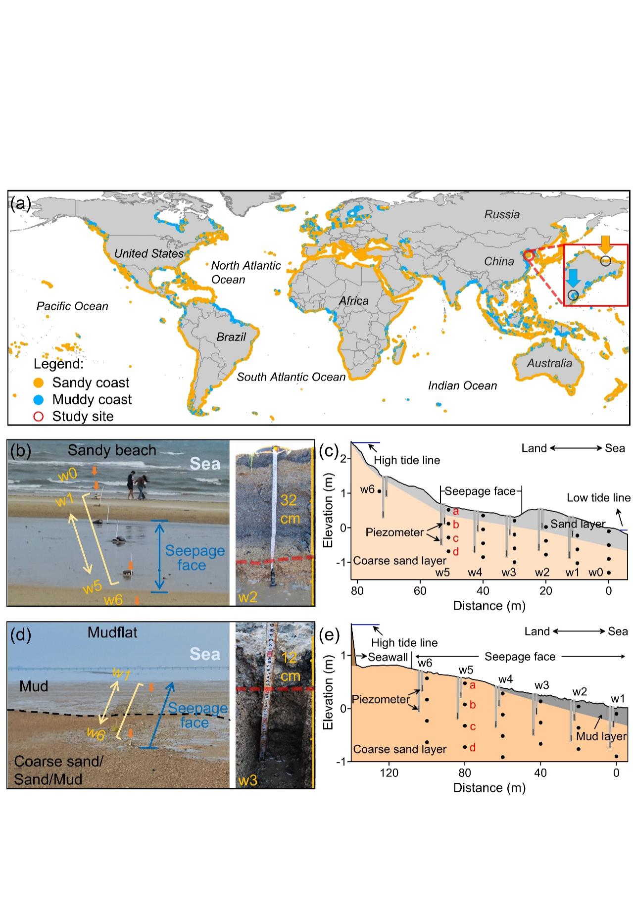
Figure. 4. Geographical location, site characteristics, and sampling point distribution of the study area
Research results indicate distinct spatial distribution differences in nutrients and carbon within the groundwater between the fine-grained and coarse-grained layers in both sandy and muddy beaches (Figure 5). In sandy beaches, groundwater composition shifts from being dominated by NO3- in the deep coarse-grained sediments (attenuated through denitrification) to being dominated by NH4+ in the surface fine-grained sediments (primarily derived from organic matter mineralization). In muddy beaches, groundwater within the fine-grained sediments also accumulated high concentrations of NH4+, PO43-, and dissolved silicon. Through the integration of methods such as cluster analysis, Mantel analysis, end-member mixing models, and isotope tracing (δ15N- NO3- and δ18O- NO3-), the study reveals that these mechanisms are a result of the synergistic regulation of hydrological dynamics and biogeochemical reactions (Figure 6).
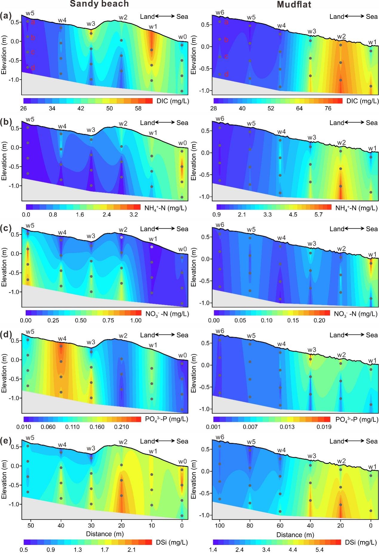
Figure. 5. Spatial distribution characteristics of DIC, NH4+, and NO3- in the groundwater profiles of sandy beach and mudflat
Additionally, sandy beaches are hot spots for groundwater discharge, with dissolved nutrient and carbon fluxes transported being two orders of magnitude higher than those from muddy beaches. The presence of fine-grained surface sediments increases the flux of DIC and NH4+ transported by groundwater, potentially exacerbating nearshore eutrophication and acidification risks (Figure 6). These findings suggest that the vertical stratification structure of intertidal sediments is a critical factor in regulating the composition and flux of nutrient and carbon transport into the sea from groundwater. It is proposed that the natural purification function of tidal flats for terrestrial nutrients can be enhanced by controlling sediment structures.

Figure. 6. Schematic diagram of nitrogen cycling in intertidal groundwater
The related research findings have been published in the Journal of Hydrology with the titles "Spatial variability of the phosphorus forms and diffusive flux across the sediment-water interface: insights from a typical small watershed to the national scale" and "Vertical sediment stratification regulates dissolved nutrient dynamics and interface fluxes along the intertidal zone." The first authors of the papers are Zheng Yan, a jointly supervised master's student from the Yantai Institute of Coastal Zone Research, and Zhenyang Li, a Ph.D. student in the 2024 cohort, respectively. The corresponding author is Researcher Kai Xiao. This research was supported by the National Natural Science Foundation of China, the Taishan Scholars Program, the Youth Program of the Talent Introduction Plan of the Chinese Academy of Sciences, the Ministry of Education of China, the Open Fund of the Qingdao Key Laboratory of Groundwater Resources Protection and Rehabilitation in Qingdao, and provincial and municipal science and technology programs.
Paper Information:
Zheng Yan, Jidong Zheng, Zhenyang Li, Jiahao Chen, Man Zhao, Jingjing Lv, Zhenyan Wang, Feng Pan, Kai Xiao, (2026). Spatial variability of the phosphorus forms and diffusive flux across the sediment–water interface: insights from a typical small watershed to the national scale. Journal of Hydrology 665, 134642. https://doi.org/10.1016/j.jhydrol.2025.134642
Zhenyang Li, Yueqi Wang, Yashu Qi, Kai Xiao, Guangxuan Han, Hailong Li, Liang Liu, Dejuan Jiang, Xiaoying Zhang, Chunmiao Zheng, (2026). Vertical sediment stratification regulates dissolved nutrient dynamics and interface fluxes along the intertidal zone. Journal of Hydrology 668, 134980. https://doi.org/10.1016/j.jhydrol.2026.134980