| Research |
| Location:Home > Research > Research Progress |
| New progress in the analysis of coastal shoreline changes in Laizhou Bay |
Monitoring shoreline movements is essential for understanding the impact of anthropogenic activities and climate change on the coastal zone dynamics. Climate change and human activities make coastal areas increasingly vulnerable to flooding and coastal erosion. In coastal planning and management, the monitoring and prediction of coast-line changes are of great importance. In the past decade, an increasing number of new technological approaches have been applied to detect and monitor changes in coastlines. Laizhou Bay, which lies south of the Bohai Sea and on the northern side of the Shandong Peninsula, is part of China’s Bohai Sea Economic Rim. Previous studies on this region have shown that Laizhou Bay has undergone significant coastal changes over the last half century.
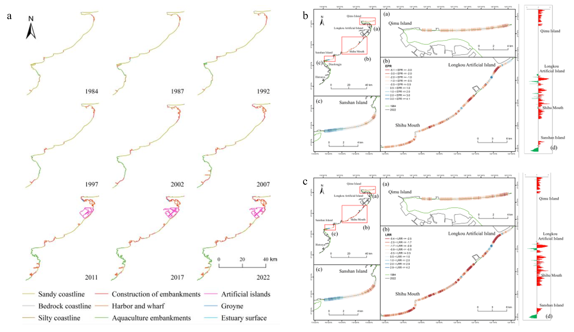
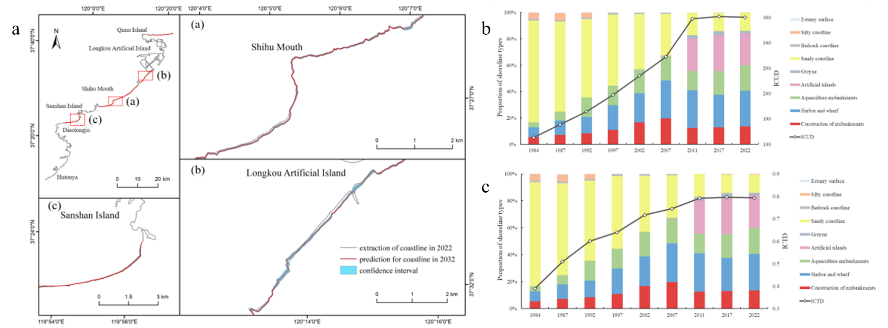
A shoreline automatic extraction method was developed and studied for the east coast of Laizhou Bay. The method utilized the Otsu algorithm, MSI boundary extraction algorithm, and tidal correction model to obtain the coastline from 1984 to 2022. The study analyzed the degree of coastline change by calculating the Length Change Intensity index (LCI), End point Rate (EPR), and Linear Regression Rate (LRR). The reasons for coastline changes were analyzed using the Index of Coastline Type Diversity (ICTD) and Index of Coastline Utilization Degree (ICUD). The integrated analysis of the coastline changes was based on calculating specific indices, while Kalman filtering. The results indicate that 89.63% of the extracted shoreline segments have an error less than 30 m compared to the manually drawn coastline. The total length of the coastline increased from 166.90 km to 364.20 km, throughout the observation period, with a length change intensity (LCI) of 3.11% due to the development of coastal protection and engineering structures for human activities. The anthropization led to a decrease in the natural coastline from 83.33% to 13.89% and a continuous increase in the diversity and human use of the coastline. In particular, the index of coastline di-versity (ICTD) and the index of coastline utilization degree (ICUD) increased from 0.39 to 0.79, and from 153.30 to 390.37, respectively. Over 70% of the sandy beaches experienced erosional processes. The shoreline erosion calculated using the end point rate (EPR) and the linear regression rate (LRR) is 79.54% and 85.58%, respectively (Figure 1). The fractal dimension of the coastline shows an increasing trend and is positively correlated with human activities. Coastline changes are primarily attributed to interventions such as land reclamation, aquaculture development, and port construction resulting in the creation of 10,000.20 hectares of new coastal areas. Finally, the use of Kalman filtering for the first time made it possible to predict that approximately 84.58% of the sandy coastline will be eroded to varying degrees by 2032. The research results can provide valuable reference for the scientific planning and rational utilization of resources on the eastern coast of Laizhou Bay (Figure 2).
Figure 1: Spatial distribution of the coastline in the study area from 1984 to 2022 (a); Erosion and accretion of sandy coastlines in the region calculated by EPR (b); Erosion and accretion of sandy coastlines in the region calculated by LRR (c).
Figure 2: Prediction of the coastline in 2032 using the Kalman filter (a); Relationship between the proportion of coastline types and ICUD (b); Relationship between the proportion of coastline types and ICTD (c).
The results of this study can provide valuable reference for the scientific planning and resource utilization of the coastal zone of Laizhou Bay. This work is one of the interim results of the China-Italy cooperation project "Coastal system changes over the Anthropocene: Natural Vs Induced drivers in China and Italy" with the Italian collaborator being Dr. Sandra Donnici and Dr. Luigi Tosi from the Institute of Geosciences and Earth Resources, National Research Council of Italy. Supported by the National Natural Science Foundation of China (U2106211), the Key Program of National Science Foundation (No. 41530966) and the seed project of Yantai Institute of Coastal Zone Research, Chinese Academy of Sciences (Grant No. YIC E351030601). The related results were published in the international journal "Remote Sensing" (Ke Mu et al, 2023), which is a Q2 journal in the field of remote sensing.
References Mu, K.; Tang, C.; Tosi, L.; Li, Y.; Zheng, X.; Donnici, S.; Sun, J.; Liu, J.; Gao, X. Coastline Monitoring and Prediction Based on Long-Term Remote Sensing Data—A Case Study of the Eastern Coast of Laizhou Bay, China. Remote Sens. 2024, 16, 185. https://doi.org/10.3390/rs16010185
|
| Appendix Download |
|
|